Places to visit in Datça
Datça is more than its sea. An ancient city where the Aegean meets the Mediterranean, an old town of stone lanes, villages that smell of almonds and olives — this is the peninsula's real story.
History and heritage
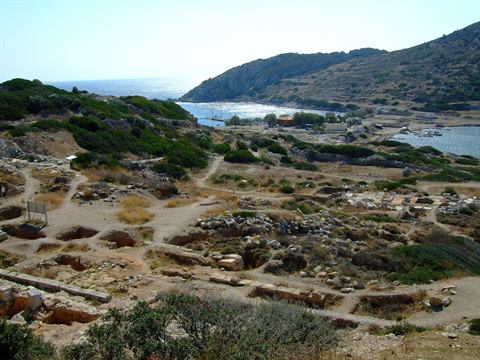
Knidos Ancient City
An ancient Carian city at the very tip of the peninsula, where the Aegean meets the Mediterranean. The astronomer Eudoxus and Sostratus, architect of the Lighthouse of Alexandria, came from here. You can see theatre ruins, temples and an ancient sundial, and swim in the cove beside it. Opening hours change with the season, so check before you set out.
Deveboynu Lighthouse
Working since 1931 on Deveboynu Cape at the tip of Knidos. The nine-metre tower stands 104 metres above sea level and its light carries 10 nautical miles. It marks the point where the Aegean meets the Mediterranean. Run by the Turkish coastal safety authority; the tower and keeper's house are listed buildings and closed to visitors, so the view is enjoyed from the cape.
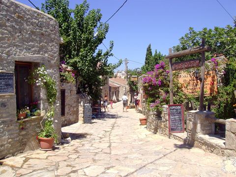
Old Datça
Stone houses, narrow lanes and bougainvillea-covered walls. The poet Can Yücel spent his final years here; his house is still private property and closed inside. Small cafés, craft shops and a quiet late-afternoon atmosphere make it the most photogenic corner of Datça.
Can Yücel's House
The stone house where the poet Can Yücel spent his last years sits on Dere Street, in the narrow lanes of Eski Datça. The verses written on its facade can be read from the road. The house is still private family property and closed inside, so visitors photograph it from the lane. Orhan's Coffee House, a few steps away, was the poet's regular spot.
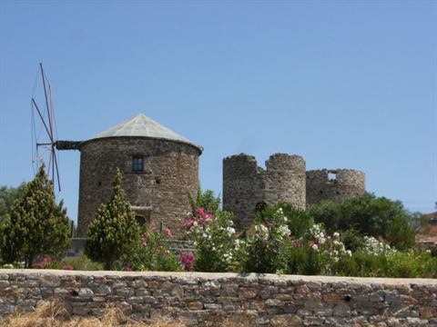
Kızlan Windmills
The stone windmills that became a symbol of Datça. For centuries they harnessed the peninsula's constant wind to grind flour; today they are best known for their sunset views.
Villages and local life
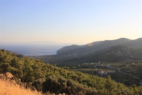
Mesudiye
The village that opens onto the Ovabükü and Hayıtbükü coves — one of the liveliest settlements in the south, where you can have both the sea and village life in a single day.
Reşadiye
One of Datça's oldest settlements. Its olive groves, almond trees and traditional stone architecture tell the peninsula's farming story better than anywhere.
Hızırşah
A small village with a historic mosque and quiet streets. Away from the tourist crowds, it is the place to see everyday Datça village life.
Yazıköy
The last village on the road to Knidos, known for its almonds and olive oil. A good stop to pick up local produce from roadside stalls.
Aktur
A holiday village at Kurucabük near Emecik, 26 km from Datça centre. It opened in 1976 and today holds around 1,250 holiday homes, two hotels and a campsite. The island of Symi lies opposite. A walkway runs along the shore and parts of the beach are open to common use.
Everyday Datça
Datça Marina & Harbour
The yacht harbour sits right beside the beach. An evening stroll along the front, a coffee at sunset and the fish restaurants around it make this the heart of town.
Kairos Marina
The peninsula's main port sits at Körmen, about 10 km from Datça centre. It offers 246 berths at sea and 256 on land, with water, electricity, fuel, Wi-Fi, showers, laundry, a restaurant and a 100-tonne crane. Call on VHF 72. The northern quay is reserved for ferry services.
Datça Market
The best place for Datça almonds, olive oil, almond paste, honey and village produce — a weekly market where you meet the peninsula's growers directly.
Datça Seafront
The promenade running from Kumluk to the marina. Cafés, ice-cream shops and the evening crowd make it the most social stretch in Datça.
The Karia Way and walking routes
The Karia Way is a waymarked long-distance trail along the Muğla coast; the segments crossing the Datça peninsula are listed below. You can download each GPS track from Wikiloc onto your phone. In midsummer avoid walking at midday — start early and carry at least two litres of water per person.
Karia Way #10 — Eski Datça / Domuzçukuru
The official segment starting at Eski Datça just east of town, crossing olive groves and maquis slopes down to Domuzçukuru cove. Waymarked, and the trailhead is reachable by bus.
Open the GPS track on Wikiloc ›Karia Way #10A — Datça / Kargı / Domuzçukuru
An alternative line to the same destination, leaving town via Kargı Cove. It hugs the coast more closely, so a cooling-off stop is easy on hot days.
Open the GPS track on Wikiloc ›Karia Way #11 — Domuzçukuru / Palamutbükü
A steep, largely shadeless stretch linking two of the peninsula's best-known coves. Carry plenty of water — springs along the way are all but nonexistent.
Open the GPS track on Wikiloc ›Karia Way #12 — Palamutbükü / Knidos
The official segment running from Palamutbükü out to ancient Knidos at the western tip of the peninsula. Exposed to the wind — an early start is best.
Open the GPS track on Wikiloc ›Karia Way #13 — Knidos / Mersincik
From Deveboynu Cape north to Mersincik on the Aegean shore. This is the loneliest part of the peninsula, with patchy phone coverage — do not walk it alone.
Open the GPS track on Wikiloc ›Karia Way #14 — Mersincik / Karaköy
Following the Aegean shore towards Karaköy, where Körmen Port sits. It ends near the ferry pier, so getting back at the end of the day is easy.
Open the GPS track on Wikiloc ›Karia Way #15 — Karaköy / Datça
The gentlest section of the route, returning from Körmen to town. A good introduction for beginners or for anyone with only half a day.
Open the GPS track on Wikiloc ›Karia Way #16 — Datça / Emecik
Running east from town to the village of Emecik, through almond and olive groves — at its best in spring when they are in blossom.
Open the GPS track on Wikiloc ›The Kara Dağ climb and its castle
The summit south of Hızırşah, looking out over both the Aegean and the Mediterranean from the spine of the peninsula. At the top stands a Byzantine castle: parts of the east and north walls are still up, and inside are building stones and three cisterns — one holds water for most of the year. In a cave on the northern slope there is a fresco thought to date from the early Christian period. In local sources the castle is usually called Yarıkdağ Kalesi. The walk starts from Hızırşah; there is no road to the summit.
Trailhead › Open the summit in maps ›Kovanlık Nature Park
The official nature park at Aktur, with short waymarked walks through pine forest. Access is limited to those staying in the area.
Open in maps ›Daily boat tour routes
Boats leave from Datça Yacht Harbour, and there are two classic routes. The times below show how a typical day runs — they vary between boats and with the weather, so confirm when you book. Do not confuse these with the Bodrum ferry, which sails from Körmen.
Short tour — the coves
The classic day trip from Datça harbour around the southern coves. Lunch is usually included, though it varies from boat to boat.
Long tour — the Knidos route
A full-day route that calls at ancient Knidos. The site entrance fee is usually not included in the tour price, so bring some cash.
Tickets are usually sold at the harbour in the morning; in the busy weeks of the season it is safer to book a day ahead. Bring a hat, high-factor sunscreen and water shoes — most of the coves are pebbly.
Useful to know
The road to Knidos is long and winding — roughly 35–40 km from town. Allow more than half a day and set out early.
Old Datça is at its best in late afternoon and at sunset. At midday the lanes are empty but there is little shade.
Renting a car is the most practical way to move between villages. Public transport exists but runs infrequently.
Datça almonds and almond paste are fresher and cheaper straight from the village stalls.
Most Karia Way segments have neither shade nor a water source. Start early, and check the village bus times for your return before you set off.
Photo Credits
- Knidos-Häfen — Tischbeinahe, CC BY-SA 3.0 · Wikimedia Commons
- Old Datca - Eski Datça - panoramio — Semih Ekinci, CC BY-SA 3.0 · Wikimedia Commons
- Datça yeldeğirmeni 1 — Nosferatü, Public domain · Wikimedia Commons
- Mesudiye, Landkreis Datça; Provinz Muğla — Christian1311, CC BY-SA 4.0 · Wikimedia Commons